Interpreting the Evidence
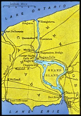
Map of the Niagara River and the Welland Canal, c. 1900
Suggested Teaching Instructions
Document Description
A map of the Niagara River and Welland Canal, circa 1900.
Historical Context
The Niagara River was formed some 12,000 years ago from water melting off glaciers. The river flows thirty-four miles from Lake Erie into Lake Ontario. Along those thirty-four miles, the river makes a sudden large drop in elevation, called Niagara Falls. Downriver from the falls, the river makes a 90º turn that is known as the Whirlpool.
Essential Question
How does geography impact culture and economic systems?
Check for Understanding
Summarize the information contained in the map and explain the influence of this water source on New York's culture and economy.